Trail Walking Viviès - 2021-05-13_10h02m05_0Axy4TJm2zc - Photo

2021-05-13_10h02m05_0Axy4TJm2zc

 ch2slv
ch2slv

User

© OpenStreetMap contributors
Length
Length
6.2 km
Max alt
Max alt
473 m
Uphill gradient
Uphill gradient
210 m
Km-Effort
Km-Effort  
9 km
Min alt
Min alt
296 m
Downhill gradient
Downhill gradient
210 m
Boucle
Boucle
Yes
Creation date :
2021-05-13 08:02:06.124
Updated on :
2021-05-14 15:24:30.107

(1 Reviews)

Walking
Walking
2h03
Difficulty : Medium

Scan this QR Code to open this trail in the SityTrail application

FREE GPS app for hiking

Logo SityTrail SityTrail

IGN / Geographical institutes

Download SityTrail from the App Store Download SityTrail from Google Play

Logo SityTrail SityTrail Plus

The world is yours!

Download SityTrail from the App Store Download SityTrail from Google Play Download SityTrail on Huawei AppGallery

About

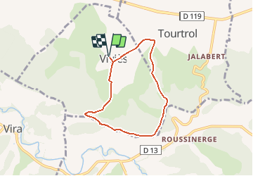
Trail Walking of 6.2 km to be discovered at Occitania, Ariège, Viviès. This trail is proposed by ch2slv.

Description

Beaucoup de sous-bois et vue très dégagée depuis la crête avec les Pyrénées ( -enneigées) en toile de fond.
Le tracé se trompe à un moment en voulant suivre l'ancien tracé.
Il faut continuer tout droit sur la G de la haie, jusqu'en haut et passer par la barrière en bois.

Elevation profile

Positioning

Country:
France
Region :
Occitania
Department/Province :
Ariège
Municipality :
Viviès
Location:
Unknown
Start:(UTM)
400842 ; 4768679 (31T) N.

Comments

Please log in to post a review or rate the element


Rando très sympa mais 1 partie du trajet n'existe pas. Je mets le tracé exact sur : "Autour de Vivies 2"


Close
My subscriptions