
ADEPS Saint Hubert

Bernard Gillet
User GUIDE

Length
10.8 km

Max alt
520 m

Uphill gradient
221 m
Km-Effort
13.7 km

Min alt
390 m

Downhill gradient
226 m
Boucle
Yes
Creation date :
2021-05-13 06:34:40.38
Updated on :
2021-05-13 08:37:27.376
1h57
Difficulty : Difficult

FREE GPS app for hiking
 SityTrail
IGN / Geographical institutes
SityTrail Plus
The world is yours!
About
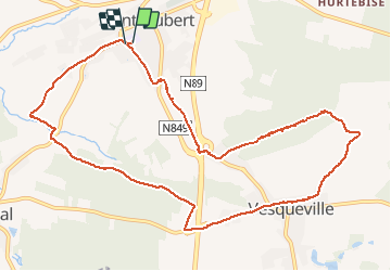
Trail Walking of 10.8 km to be discovered at Wallonia, Luxembourg, Saint-Hubert. This trail is proposed by Bernard Gillet.
Description
Très beau parcours de 10km700.
Très bon fléchage.
Photos


21 photos in total. Please click on a photo to see them all in the gallery.
Positioning
Country:
Belgium
Region :
Wallonia
Department/Province :
Luxembourg
Municipality :
Saint-Hubert
Location:
Saint-Hubert
Start:(Dec)
Start:(UTM)
669891 ; 5543869 (31U) N.
Comments