


Hamel Lécluse

BrassensJC
User
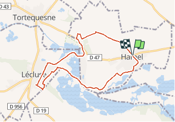

Length
7.9 km

Max alt
68 m

Uphill gradient
52 m
Km-Effort
8.6 km

Min alt
35 m

Downhill gradient
50 m
Boucle
Yes
Creation date :
2021-05-13 13:01:39.631
Updated on :
2021-05-13 13:02:06.197
1h57
Difficulty : Medium

FREE GPS app for hiking
 SityTrail
IGN / Geographical institutes
SityTrail Plus
The world is yours!
About
Trail Walking of 7.9 km to be discovered at Hauts-de-France, Nord, Hamel. This trail is proposed by BrassensJC.
Positioning
Country:
France
Region :
Hauts-de-France
Department/Province :
Nord
Municipality :
Hamel
Location:
Unknown
Start:(Dec)
Start:(UTM)
505268 ; 5569859 (31U) N.
Comments