


chaumint

bendoush
User
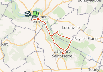

Length
11.8 km

Max alt
106 m

Uphill gradient
167 m
Km-Effort
14 km

Min alt
63 m

Downhill gradient
165 m
Boucle
Yes
Creation date :
2021-05-13 10:16:47.738
Updated on :
2021-05-13 13:34:14.275
3h16
Difficulty : Difficult

FREE GPS app for hiking
 SityTrail
IGN / Geographical institutes
SityTrail Plus
The world is yours!
About
Trail Walking of 11.8 km to be discovered at Hauts-de-France, Oise, Chaumont-en-Vexin. This trail is proposed by bendoush.
Positioning
Country:
France
Region :
Hauts-de-France
Department/Province :
Oise
Municipality :
Chaumont-en-Vexin
Location:
Unknown
Start:(Dec)
Start:(UTM)
417963 ; 5457155 (31U) N.
Comments