


2021-05-13_16h41m33_puys des gouttes et de chopine

jpcccb
User
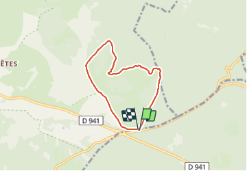

Length
5.8 km

Max alt
1123 m

Uphill gradient
181 m
Km-Effort
8.2 km

Min alt
949 m

Downhill gradient
180 m
Boucle
Yes
Creation date :
2021-05-13 14:41:33.992
Updated on :
2021-09-14 16:13:17.493
1h51
Difficulty : Medium

FREE GPS app for hiking
 SityTrail
IGN / Geographical institutes
SityTrail Plus
The world is yours!
About
Trail Walking of 5.8 km to be discovered at Auvergne-Rhône-Alpes, Puy-de-Dôme, Orcines. This trail is proposed by jpcccb.
Positioning
Country:
France
Region :
Auvergne-Rhône-Alpes
Department/Province :
Puy-de-Dôme
Municipality :
Orcines
Location:
Unknown
Start:(Dec)
Start:(UTM)
496730 ; 5073391 (31T) N.
Comments