


Coye forêt Pontarmé et Comelles

domifon
User
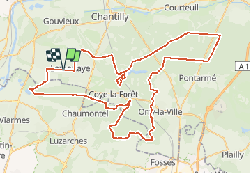

Length
50 km

Max alt
143 m

Uphill gradient
583 m
Km-Effort
58 km

Min alt
27 m

Downhill gradient
581 m
Boucle
Yes
Creation date :
2021-05-13 12:33:04.0
Updated on :
2021-05-13 14:59:54.801
2h25
Difficulty : Medium

FREE GPS app for hiking
 SityTrail
IGN / Geographical institutes
SityTrail Plus
The world is yours!
About
Trail Mountain bike of 50 km to be discovered at Hauts-de-France, Oise, Lamorlaye. This trail is proposed by domifon.
Positioning
Country:
France
Region :
Hauts-de-France
Department/Province :
Oise
Municipality :
Lamorlaye
Location:
Unknown
Start:(Dec)
Start:(UTM)
457623 ; 5445164 (31U) N.
Comments