


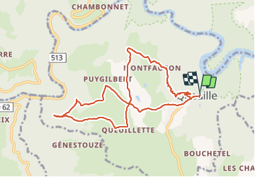
2021-05-13_17h15m59_boucle de queuille

jpcccb
User

Length
9.8 km

Max alt
700 m

Uphill gradient
269 m
Km-Effort
13.3 km

Min alt
590 m

Downhill gradient
268 m
Boucle
Yes
Creation date :
2021-05-13 15:15:59.401
Updated on :
2021-09-14 16:10:42.505
3h01
Difficulty : Difficult

FREE GPS app for hiking
 SityTrail
IGN / Geographical institutes
SityTrail Plus
The world is yours!
About
Trail Walking of 9.8 km to be discovered at Auvergne-Rhône-Alpes, Puy-de-Dôme, Queuille. This trail is proposed by jpcccb.
Positioning
Country:
France
Region :
Auvergne-Rhône-Alpes
Department/Province :
Puy-de-Dôme
Municipality :
Queuille
Location:
Unknown
Start:(Dec)
Start:(UTM)
488293 ; 5090960 (31T) N.
Comments