


2021-05-13_17h16m12_Le plateau de gergovie

jpcccb
User
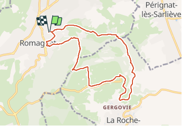

Length
9.6 km

Max alt
727 m

Uphill gradient
327 m
Km-Effort
14 km

Min alt
468 m

Downhill gradient
327 m
Boucle
Yes
Creation date :
2021-05-13 15:16:12.301
Updated on :
2021-09-14 16:10:04.155
3h10
Difficulty : Difficult

FREE GPS app for hiking
 SityTrail
IGN / Geographical institutes
SityTrail Plus
The world is yours!
About
Trail Walking of 9.6 km to be discovered at Auvergne-Rhône-Alpes, Puy-de-Dôme, Romagnat. This trail is proposed by jpcccb.
Positioning
Country:
France
Region :
Auvergne-Rhône-Alpes
Department/Province :
Puy-de-Dôme
Municipality :
Romagnat
Location:
Unknown
Start:(Dec)
Start:(UTM)
507985 ; 5064122 (31T) N.
Comments