


Puygros-2021-05-13

Valmeinier
User
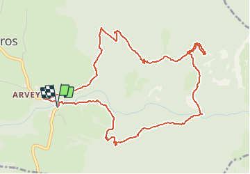

Length
6.4 km

Max alt
1354 m

Uphill gradient
543 m
Km-Effort
13.6 km

Min alt
796 m

Downhill gradient
541 m
Boucle
Yes
Creation date :
2021-05-14 05:53:42.449
Updated on :
2021-05-14 06:10:32.699
--
Difficulty : Unknown

FREE GPS app for hiking
 SityTrail
IGN / Geographical institutes
SityTrail Plus
The world is yours!
About
Trail Walking of 6.4 km to be discovered at Auvergne-Rhône-Alpes, Savoy, Puygros. This trail is proposed by Valmeinier.
Photos


Positioning
Country:
France
Region :
Auvergne-Rhône-Alpes
Department/Province :
Savoy
Municipality :
Puygros
Location:
Unknown
Start:(Dec)
Start:(UTM)
269163 ; 5049578 (32T) N.
Comments