


GTVAU-J1 long

PhilippeC54
User
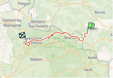

Length
39 km

Max alt
1012 m

Uphill gradient
1332 m
Km-Effort
58 km

Min alt
327 m

Downhill gradient
1756 m
Boucle
No
Creation date :
2021-05-15 13:22:57.355
Updated on :
2021-05-15 13:23:22.371
--
Difficulty : Unknown

FREE GPS app for hiking
 SityTrail
IGN / Geographical institutes
SityTrail Plus
The world is yours!
About
Trail Mountain bike of 39 km to be discovered at Auvergne-Rhône-Alpes, Drôme, Montbrun-les-Bains. This trail is proposed by PhilippeC54.
Positioning
Country:
France
Region :
Auvergne-Rhône-Alpes
Department/Province :
Drôme
Municipality :
Montbrun-les-Bains
Location:
Unknown
Start:(Dec)
Start:(UTM)
692037 ; 4897956 (31T) N.
Comments