


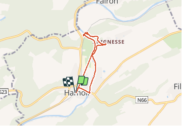
Circuit Tabreux

Michel GUISSE
User

Length
4.8 km

Max alt
144 m

Uphill gradient
44 m
Km-Effort
5.4 km

Min alt
108 m

Downhill gradient
45 m
Boucle
Yes
Creation date :
2021-05-15 12:41:36.0
Updated on :
2021-05-15 15:00:22.456
1h35
Difficulty : Easy

FREE GPS app for hiking
 SityTrail
IGN / Geographical institutes
SityTrail Plus
The world is yours!
About
Trail Walking of 4.8 km to be discovered at Wallonia, Liège, Hamoir. This trail is proposed by Michel GUISSE.
Description
Rive Dr - Crahoûte - Tabreux - Ravel
Positioning
Country:
Belgium
Region :
Wallonia
Department/Province :
Liège
Municipality :
Hamoir
Location:
Hamoir
Start:(Dec)
Start:(UTM)
679862 ; 5589017 (31U) N.
Comments