


Amicale_Lacenas

d.rognon
User
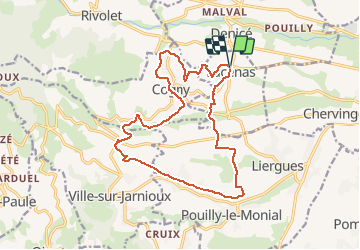

Length
17.3 km

Max alt
426 m

Uphill gradient
458 m
Km-Effort
23 km

Min alt
259 m

Downhill gradient
457 m
Boucle
Yes
Creation date :
2021-05-15 15:25:59.809
Updated on :
2021-05-20 19:41:47.822
5h19
Difficulty : Very difficult

FREE GPS app for hiking
 SityTrail
IGN / Geographical institutes
SityTrail Plus
The world is yours!
About
Trail Walking of 17.3 km to be discovered at Auvergne-Rhône-Alpes, Rhône, Lacenas. This trail is proposed by d.rognon.
Description
Date de réalisation : 18 mai 2021
Positioning
Country:
France
Region :
Auvergne-Rhône-Alpes
Department/Province :
Rhône
Municipality :
Lacenas
Location:
Unknown
Start:(Dec)
Start:(UTM)
627437 ; 5094582 (31T) N.
Comments