


Marcouray

AnneCecile
User
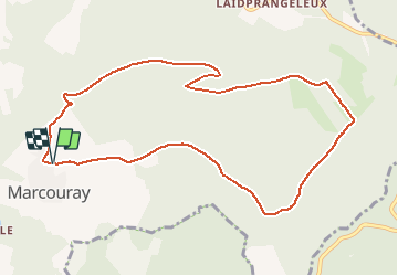

Length
9.7 km

Max alt
534 m

Uphill gradient
298 m
Km-Effort
13.7 km

Min alt
260 m

Downhill gradient
292 m
Boucle
Yes
Creation date :
2021-05-15 15:50:28.664
Updated on :
2021-05-15 16:11:43.14

FREE GPS app for hiking
 SityTrail
IGN / Geographical institutes
SityTrail Plus
The world is yours!
About
Trail of 9.7 km to be discovered at Wallonia, Luxembourg, Rendeux. This trail is proposed by AnneCecile.
Positioning
Country:
Belgium
Region :
Wallonia
Department/Province :
Luxembourg
Municipality :
Rendeux
Location:
Marcourt
Start:(Dec)
Start:(UTM)
681773 ; 5565700 (31U) N.
Comments