


20210515

fredodlageo
User
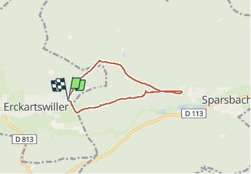

Length
5 km

Max alt
270 m

Uphill gradient
74 m
Km-Effort
6 km

Min alt
222 m

Downhill gradient
80 m
Boucle
Yes
Creation date :
2021-05-15 16:14:56.0
Updated on :
2021-05-15 17:01:46.043
46m
Difficulty : Unknown

FREE GPS app for hiking
 SityTrail
IGN / Geographical institutes
SityTrail Plus
The world is yours!
About
Trail Trail of 5 km to be discovered at Grand Est, Bas-Rhin, Erckartswiller. This trail is proposed by fredodlageo.
Description
Cross avec Izzie
Positioning
Country:
France
Region :
Grand Est
Department/Province :
Bas-Rhin
Municipality :
Erckartswiller
Location:
Unknown
Start:(Dec)
Start:(UTM)
380920 ; 5415154 (32U) N.
Comments