


st simon

JEANPAULVALENTIN
User
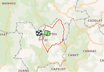

Length
10.1 km

Max alt
785 m

Uphill gradient
274 m
Km-Effort
13.8 km

Min alt
535 m

Downhill gradient
274 m
Boucle
Yes
Creation date :
2021-05-15 17:31:42.508
Updated on :
2025-04-28 09:02:38.881
3h07
Difficulty : Easy

FREE GPS app for hiking
 SityTrail
IGN / Geographical institutes
SityTrail Plus
The world is yours!
About
Trail On foot of 10.1 km to be discovered at Auvergne-Rhône-Alpes, Cantal, Vitrac. This trail is proposed by JEANPAULVALENTIN.
Positioning
Country:
France
Region :
Auvergne-Rhône-Alpes
Department/Province :
Cantal
Municipality :
Vitrac
Location:
Unknown
Start:(Dec)
Start:(UTM)
445825 ; 4962650 (31T) N.
Comments