


w-frankrijk-over-dijken-en-kwelders

gpstracks
User
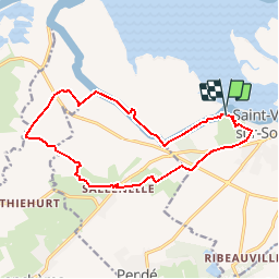

Length
13.8 km

Max alt
35 m

Uphill gradient
77 m
Km-Effort
14.9 km

Min alt
0 m

Downhill gradient
77 m
Boucle
Yes
Creation date :
2014-12-10 00:00:00.0
Updated on :
2014-12-10 00:00:00.0
--
Difficulty : Unknown

FREE GPS app for hiking
 SityTrail
IGN / Geographical institutes
SityTrail Plus
The world is yours!
About
Trail Walking of 13.8 km to be discovered at Hauts-de-France, Somme, Saint-Valery-sur-Somme. This trail is proposed by gpstracks.
Description
More information on GPStracks.nl : http://www.gpstracks.nl


Positioning
Country:
France
Region :
Hauts-de-France
Department/Province :
Somme
Municipality :
Saint-Valery-sur-Somme
Location:
Unknown
Start:(Dec)
Start:(UTM)
400943 ; 5560714 (31U) N.
Comments
Joli cheminement dans les marais