


tour Montgueuliatte 16/5/21

Tollard
User
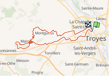

Length
41 km

Max alt
274 m

Uphill gradient
556 m
Km-Effort
48 km

Min alt
98 m

Downhill gradient
555 m
Boucle
Yes
Creation date :
2021-05-16 06:31:23.529
Updated on :
2021-05-16 09:58:39.945
3h09
Difficulty : Easy

FREE GPS app for hiking
 SityTrail
IGN / Geographical institutes
SityTrail Plus
The world is yours!
About
Trail Mountain bike of 41 km to be discovered at Grand Est, Aube, Troyes. This trail is proposed by Tollard.
Description
Singles classic MONTGUEUX/MACEY
Positioning
Country:
France
Region :
Grand Est
Department/Province :
Aube
Municipality :
Troyes
Location:
Unknown
Start:(Dec)
Start:(UTM)
579133 ; 5351046 (31U) N.
Comments