Saint Aubin Les deux GR page 15

grasgilbert
User
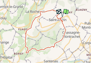

Length
16.9 km

Max alt
514 m

Uphill gradient
441 m
Km-Effort
23 km

Min alt
274 m

Downhill gradient
441 m
Boucle
Yes
Creation date :
2021-05-17 13:22:47.729
Updated on :
2021-08-05 15:08:41.822
5h10
Difficulty : Medium

FREE GPS app for hiking
 SityTrail
IGN / Geographical institutes
SityTrail Plus
The world is yours!
About
Trail On foot of 16.9 km to be discovered at Bourgogne-Franche-Comté, Côte-d'Or, Saint-Aubin. This trail is proposed by grasgilbert.
Positioning
Country:
France
Region :
Bourgogne-Franche-Comté
Department/Province :
Côte-d'Or
Municipality :
Saint-Aubin
Location:
Unknown
Start:(Dec)
Start:(UTM)
630543 ; 5201290 (31T) N.
Comments