


Charrecey le Chateau de Montaigu page 46

grasgilbert
User
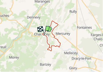

Length
18.2 km

Max alt
417 m

Uphill gradient
506 m
Km-Effort
25 km

Min alt
270 m

Downhill gradient
505 m
Boucle
Yes
Creation date :
2021-05-17 14:00:38.453
Updated on :
2021-08-05 15:08:04.634
5h39
Difficulty : Medium

FREE GPS app for hiking
 SityTrail
IGN / Geographical institutes
SityTrail Plus
The world is yours!
About
Trail On foot of 18.2 km to be discovered at Bourgogne-Franche-Comté, Saône-et-Loire, Charrecey. This trail is proposed by grasgilbert.
Positioning
Country:
France
Region :
Bourgogne-Franche-Comté
Department/Province :
Saône-et-Loire
Municipality :
Charrecey
Location:
Unknown
Start:(Dec)
Start:(UTM)
627678 ; 5188357 (31T) N.
Comments