


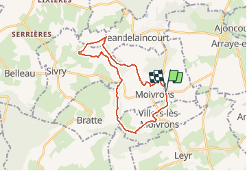
Circuit panoramique autour de Moivrons

ZAMBAUX
User

Length
12.7 km

Max alt
406 m

Uphill gradient
327 m
Km-Effort
17.1 km

Min alt
229 m

Downhill gradient
327 m
Boucle
Yes
Creation date :
2021-05-18 08:21:46.576
Updated on :
2021-05-18 08:22:46.569
3h52
Difficulty : Difficult

FREE GPS app for hiking
 SityTrail
IGN / Geographical institutes
SityTrail Plus
The world is yours!
About
Trail Walking of 12.7 km to be discovered at Grand Est, Meurthe-et-Moselle, Moivrons. This trail is proposed by ZAMBAUX.
Points of interest


Positioning
Country:
France
Region :
Grand Est
Department/Province :
Meurthe-et-Moselle
Municipality :
Moivrons
Location:
Unknown
Start:(Dec)
Start:(UTM)
298572 ; 5411473 (32U) N.
Comments