


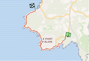
De Bandol au port d'Alon jusqu'à la Madrague de St Cyr (aller)

Robertplessier
User


2h00
Difficulty : Medium

FREE GPS app for hiking
 SityTrail
IGN / Geographical institutes
SityTrail Plus
The world is yours!
About
Trail Walking of 5.9 km to be discovered at Provence-Alpes-Côte d'Azur, Var, Saint-Cyr-sur-Mer. This trail is proposed by Robertplessier.
Description
Très belle randonnée le long du littoral, entre Bandol et la Madrague de St Cyr.
Aller simple (prévoir le même temps si retour par même chemin, ou bien on peut couper par les routes dans l'intérieur au retour, mais ce n'est pas très direct quand même et beaucoup moins intéressant).
Photos
 - Photo 1")
 - Photo 2")
Positioning
Comments