


Moroges le Mont Brogny (2) page 52

grasgilbert
User
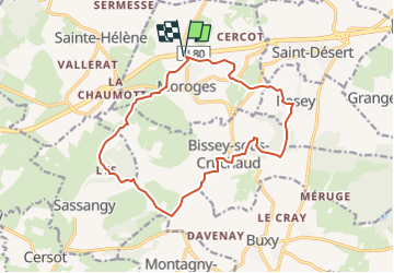

Length
15.4 km

Max alt
439 m

Uphill gradient
409 m
Km-Effort
21 km

Min alt
237 m

Downhill gradient
409 m
Boucle
Yes
Creation date :
2021-05-19 08:17:44.656
Updated on :
2023-01-26 16:57:47.612
4h47
Difficulty : Medium

FREE GPS app for hiking
 SityTrail
IGN / Geographical institutes
SityTrail Plus
The world is yours!
About
Trail On foot of 15.4 km to be discovered at Bourgogne-Franche-Comté, Saône-et-Loire, Moroges. This trail is proposed by grasgilbert.
Positioning
Country:
France
Region :
Bourgogne-Franche-Comté
Department/Province :
Saône-et-Loire
Municipality :
Moroges
Location:
Unknown
Start:(Dec)
Start:(UTM)
627582 ; 5179065 (31T) N.
Comments