


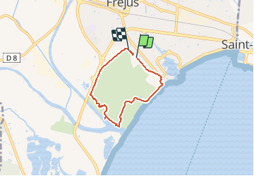
Fréjus base de loisirs

janussity
User

Length
5.2 km

Max alt
13 m

Uphill gradient
32 m
Km-Effort
5.6 km

Min alt
-2 m

Downhill gradient
32 m
Boucle
Yes
Creation date :
2021-05-19 12:38:44.863
Updated on :
2021-05-19 14:34:52.977
1h24
Difficulty : Easy

FREE GPS app for hiking
 SityTrail
IGN / Geographical institutes
SityTrail Plus
The world is yours!
About
Trail Walking of 5.2 km to be discovered at Provence-Alpes-Côte d'Azur, Var, Fréjus. This trail is proposed by janussity.
Description
Ensoleillé
Photos

Positioning
Country:
France
Region :
Provence-Alpes-Côte d'Azur
Department/Province :
Var
Municipality :
Fréjus
Location:
Unknown
Start:(Dec)
Start:(UTM)
317002 ; 4810295 (32T) N.
Comments