


roche brune

panetJeanLuc
User
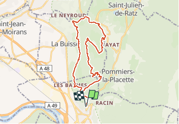

Length
18.6 km

Max alt
942 m

Uphill gradient
922 m
Km-Effort
31 km

Min alt
349 m

Downhill gradient
930 m
Boucle
Yes
Creation date :
2021-05-20 07:56:38.468
Updated on :
2021-05-20 15:37:11.817
7h37
Difficulty : Very difficult

FREE GPS app for hiking
 SityTrail
IGN / Geographical institutes
SityTrail Plus
The world is yours!
About
Trail Walking of 18.6 km to be discovered at Auvergne-Rhône-Alpes, Isère, Voreppe. This trail is proposed by panetJeanLuc.
Description
départ la placette
Positioning
Country:
France
Region :
Auvergne-Rhône-Alpes
Department/Province :
Isère
Municipality :
Voreppe
Location:
Unknown
Start:(Dec)
Start:(UTM)
706612 ; 5019971 (31T) N.
Comments