


GTVAU-PJ1

PhilippeC54
User
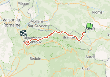

Length
42 km

Max alt
1012 m

Uphill gradient
1389 m
Km-Effort
61 km

Min alt
328 m

Downhill gradient
1771 m
Boucle
No
Creation date :
2021-05-21 07:06:32.692
Updated on :
2021-05-21 15:18:58.945
4h20
Difficulty : Very difficult

FREE GPS app for hiking
 SityTrail
IGN / Geographical institutes
SityTrail Plus
The world is yours!
About
Trail Mountain bike of 42 km to be discovered at Auvergne-Rhône-Alpes, Drôme, Montbrun-les-Bains. This trail is proposed by PhilippeC54.
Positioning
Country:
France
Region :
Auvergne-Rhône-Alpes
Department/Province :
Drôme
Municipality :
Montbrun-les-Bains
Location:
Unknown
Start:(Dec)
Start:(UTM)
692301 ; 4897639 (31T) N.
Comments