


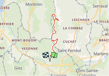
Crêt des Mouches depuis Faverges

gregou74
User

Length
13.8 km

Max alt
2023 m

Uphill gradient
1731 m
Km-Effort
37 km

Min alt
512 m

Downhill gradient
1731 m
Boucle
Yes
Creation date :
2021-05-21 15:20:49.892
Updated on :
2021-05-21 15:22:38.192
8h22
Difficulty : Very difficult

FREE GPS app for hiking
 SityTrail
IGN / Geographical institutes
SityTrail Plus
The world is yours!
About
Trail Walking of 13.8 km to be discovered at Auvergne-Rhône-Alpes, Upper Savoy, Faverges-Seythenex. This trail is proposed by gregou74.
Positioning
Country:
France
Region :
Auvergne-Rhône-Alpes
Department/Province :
Upper Savoy
Municipality :
Faverges-Seythenex
Location:
Unknown
Start:(Dec)
Start:(UTM)
288731 ; 5070725 (32T) N.
Comments