


GR573_Pacours-principal_2021-02-14

ramagufa
User

Length
124 km

Max alt
699 m

Uphill gradient
3036 m
Km-Effort
164 km

Min alt
62 m

Downhill gradient
2943 m
Boucle
No
Creation date :
2021-05-21 17:18:28.079
Updated on :
2021-05-21 17:36:38.712
37h22
Difficulty : Very difficult

FREE GPS app for hiking
 SityTrail
IGN / Geographical institutes
SityTrail Plus
The world is yours!
About
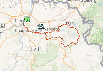
Trail Walking of 124 km to be discovered at Wallonia, Liège, Liège. This trail is proposed by ramagufa.
Description
Au départ d'Angleur pour terminer à Pépinster.
124 km et 3036 m
Positioning
Country:
Belgium
Region :
Wallonia
Department/Province :
Liège
Municipality :
Liège
Location:
Angleur
Start:(Dec)
Start:(UTM)
683936 ; 5610047 (31U) N.
Comments