


GR573_Pacours-principal_2021-02-14

ramagufa
User
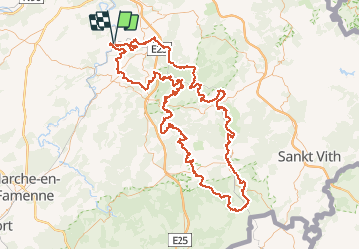

Length
186 km

Max alt
579 m

Uphill gradient
5267 m
Km-Effort
256 km

Min alt
97 m

Downhill gradient
5269 m
Boucle
Yes
Creation date :
2021-05-21 17:27:28.874
Updated on :
2021-05-21 17:34:42.965
58h16
Difficulty : Very difficult

FREE GPS app for hiking
 SityTrail
IGN / Geographical institutes
SityTrail Plus
The world is yours!
About
Trail Walking of 186 km to be discovered at Wallonia, Liège, Comblain-au-Pont. This trail is proposed by ramagufa.
Description
Itinéraire : Pont-de-Sçay - Remouchamps - Trois-Ponts - Salmchâteau - Gouvy - Lierneux - Chevron - Lorcé - Xhoris - Pont-de-Sçay
Positioning
Country:
Belgium
Region :
Wallonia
Department/Province :
Liège
Municipality :
Comblain-au-Pont
Location:
Unknown
Start:(Dec)
Start:(UTM)
683731 ; 5595171 (31U) N.
Comments