


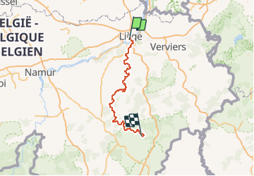
GR057_Sentier-de-l'Ourthe_Parcours-principal_2021-05-04

ramagufa
User

Length
138 km

Max alt
420 m

Uphill gradient
3712 m
Km-Effort
186 km

Min alt
53 m

Downhill gradient
3499 m
Boucle
No
Creation date :
2021-05-21 17:49:34.121
Updated on :
2021-05-24 09:10:32.479
42h23
Difficulty : Very difficult

FREE GPS app for hiking
 SityTrail
IGN / Geographical institutes
SityTrail Plus
The world is yours!
About
Trail Walking of 138 km to be discovered at Wallonia, Liège, Liège. This trail is proposed by ramagufa.
Description
138 km et 3712 m
Positioning
Country:
Belgium
Region :
Wallonia
Department/Province :
Liège
Municipality :
Liège
Location:
Unknown
Start:(Dec)
Start:(UTM)
681608 ; 5611260 (31U) N.
Comments