


Pont du bouchet le belvédère Andrivet Comps

jeanic63
User
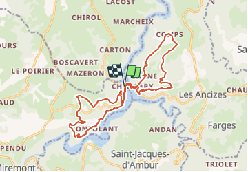

Length
19.5 km

Max alt
689 m

Uphill gradient
638 m
Km-Effort
28 km

Min alt
506 m

Downhill gradient
639 m
Boucle
Yes
Creation date :
2021-05-22 09:53:07.443
Updated on :
2021-05-30 16:12:15.735
6h33
Difficulty : Medium

FREE GPS app for hiking
 SityTrail
IGN / Geographical institutes
SityTrail Plus
The world is yours!
About
Trail On foot of 19.5 km to be discovered at Auvergne-Rhône-Alpes, Puy-de-Dôme, Miremont. This trail is proposed by jeanic63.
Description
départ pont du Bouchet
Positioning
Country:
France
Region :
Auvergne-Rhône-Alpes
Department/Province :
Puy-de-Dôme
Municipality :
Miremont
Location:
Unknown
Start:(Dec)
Start:(UTM)
482085 ; 5085996 (31T) N.
Comments