


GTVAU-PJ2

PhilippeC54
User
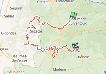

Length
43 km

Max alt
601 m

Uphill gradient
1375 m
Km-Effort
62 km

Min alt
159 m

Downhill gradient
1389 m
Boucle
No
Creation date :
2021-05-22 07:02:35.857
Updated on :
2021-05-22 15:27:46.284
4h24
Difficulty : Very difficult

FREE GPS app for hiking
 SityTrail
IGN / Geographical institutes
SityTrail Plus
The world is yours!
About
Trail Mountain bike of 43 km to be discovered at Provence-Alpes-Côte d'Azur, Vaucluse, Malaucène. This trail is proposed by PhilippeC54.
Positioning
Country:
France
Region :
Provence-Alpes-Côte d'Azur
Department/Province :
Vaucluse
Municipality :
Malaucène
Location:
Unknown
Start:(Dec)
Start:(UTM)
671659 ; 4894437 (31T) N.
Comments