


Valvignères 8km

thonyc
User GUIDE
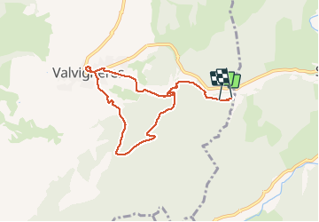

Length
7.9 km

Max alt
325 m

Uphill gradient
263 m
Km-Effort
11.5 km

Min alt
133 m

Downhill gradient
280 m
Boucle
No
Creation date :
2021-05-22 13:58:31.231
Updated on :
2021-05-22 19:51:13.429
2h22
Difficulty : Easy

FREE GPS app for hiking
 SityTrail
IGN / Geographical institutes
SityTrail Plus
The world is yours!
About
Trail Walking of 7.9 km to be discovered at Auvergne-Rhône-Alpes, Ardèche, Valvignères. This trail is proposed by thonyc.
Positioning
Country:
France
Region :
Auvergne-Rhône-Alpes
Department/Province :
Ardèche
Municipality :
Valvignères
Location:
Unknown
Start:(Dec)
Start:(UTM)
627203 ; 4928261 (31T) N.
Comments