


Bec Charvet

dansanet
User
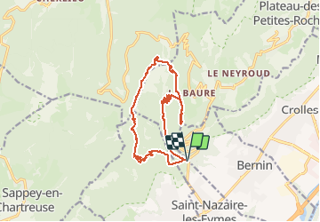

Length
17 km

Max alt
1728 m

Uphill gradient
1281 m
Km-Effort
34 km

Min alt
514 m

Downhill gradient
1282 m
Boucle
Yes
Creation date :
2021-05-23 06:44:01.082
Updated on :
2021-05-23 15:16:40.102
7h23
Difficulty : Difficult

FREE GPS app for hiking
 SityTrail
IGN / Geographical institutes
SityTrail Plus
The world is yours!
About
Trail Walking of 17 km to be discovered at Auvergne-Rhône-Alpes, Isère, Bernin. This trail is proposed by dansanet.
Positioning
Country:
France
Region :
Auvergne-Rhône-Alpes
Department/Province :
Isère
Municipality :
Bernin
Location:
Unknown
Start:(Dec)
Start:(UTM)
722846 ; 5016941 (31T) N.
Comments