


Ray pic

raygautier
User
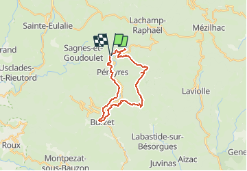

Length
24 km

Max alt
1389 m

Uphill gradient
1140 m
Km-Effort
39 km

Min alt
543 m

Downhill gradient
1140 m
Boucle
Yes
Creation date :
2021-05-23 07:30:08.0
Updated on :
2021-05-23 15:25:39.871
5h46
Difficulty : Very difficult

FREE GPS app for hiking
 SityTrail
IGN / Geographical institutes
SityTrail Plus
The world is yours!
About
Trail Walking of 24 km to be discovered at Auvergne-Rhône-Alpes, Ardèche, Péreyres. This trail is proposed by raygautier.
Positioning
Country:
France
Region :
Auvergne-Rhône-Alpes
Department/Province :
Ardèche
Municipality :
Péreyres
Location:
Unknown
Start:(Dec)
Start:(UTM)
599138 ; 4960104 (31T) N.
Comments