


Senlis 12km

Djaie60
User
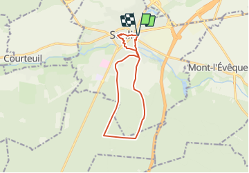

Length
11.2 km

Max alt
81 m

Uphill gradient
96 m
Km-Effort
12.5 km

Min alt
50 m

Downhill gradient
96 m
Boucle
Yes
Creation date :
2021-05-23 16:57:36.0
Updated on :
2021-06-23 09:55:00.226
2h50
Difficulty : Easy

FREE GPS app for hiking
 SityTrail
IGN / Geographical institutes
SityTrail Plus
The world is yours!
About
Trail On foot of 11.2 km to be discovered at Hauts-de-France, Oise, Senlis. This trail is proposed by Djaie60.
Positioning
Country:
France
Region :
Hauts-de-France
Department/Province :
Oise
Municipality :
Senlis
Location:
Unknown
Start:(Dec)
Start:(UTM)
470305 ; 5450473 (31U) N.
Comments