


CIRSUE XEFOSSE

surceneux
User
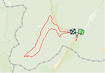

Length
9.1 km

Max alt
923 m

Uphill gradient
319 m
Km-Effort
13.3 km

Min alt
644 m

Downhill gradient
320 m
Boucle
Yes
Creation date :
2021-05-23 13:27:57.853
Updated on :
2021-05-23 18:21:35.36
2h45
Difficulty : Medium

FREE GPS app for hiking
 SityTrail
IGN / Geographical institutes
SityTrail Plus
The world is yours!
About
Trail Walking of 9.1 km to be discovered at Grand Est, Vosges, Plainfaing. This trail is proposed by surceneux.
Description
SUR UNE RANDO DE ANNE ET JEROME RENAC ( GUIDE EPATANT) MERCI A EUX🙂
DEPART ETANG DES DAMES AU RUDLIN. AUTOUR DE XEFOSSE.
Positioning
Country:
France
Region :
Grand Est
Department/Province :
Vosges
Municipality :
Plainfaing
Location:
Unknown
Start:(Dec)
Start:(UTM)
354325 ; 5331303 (32U) N.
Comments