


ST WANDRILLE 2021-05-23-01

Laurent53
User
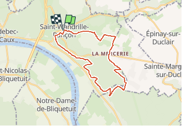

Length
14 km

Max alt
131 m

Uphill gradient
269 m
Km-Effort
17.6 km

Min alt
22 m

Downhill gradient
270 m
Boucle
Yes
Creation date :
2021-05-24 07:41:37.98
Updated on :
2021-05-24 08:35:44.525
4h36
Difficulty : Medium

FREE GPS app for hiking
 SityTrail
IGN / Geographical institutes
SityTrail Plus
The world is yours!
About
Trail On foot of 14 km to be discovered at Normandy, Seine-Maritime, Rives-en-Seine. This trail is proposed by Laurent53.
Positioning
Country:
France
Region :
Normandy
Department/Province :
Seine-Maritime
Municipality :
Rives-en-Seine
Location:
Unknown
Start:(Dec)
Start:(UTM)
338378 ; 5488466 (31U) N.
Comments