![](/images/other/stat-length.png)
![Trail Walking Aachen - Trois-Frontières - Photo](https://media.geolcdn.com/t/1900/400/ext.pjpeg?maxdim=2&url=https%3A%2F%2Fmedia.geolcdn.com%2Ff%2F6a3cd819-e18b-4021-9b52-797f29cdc2e1.jpg)
Trois-Frontières
mumu.larandonneuse
User GUIDE
![Length](/images/other/stat-length.png)
Length
15.7 km
![Max alt](https://static1.geolcdn.com/siteimages/upload/files/1508320355ic_sort_altitude_max_24dp.png)
Max alt
351 m
![Uphill gradient](https://static1.geolcdn.com/siteimages/upload/files/1508320355ic_sort_den_pos_24dp.png)
Uphill gradient
342 m
![Km-Effort](/images/other/stat-length.png)
Km-Effort
20 km
![Min alt](https://static1.geolcdn.com/siteimages/upload/files/1508320355ic_sort_altitude_min_24dp.png)
Min alt
183 m
![Downhill gradient](https://static1.geolcdn.com/siteimages/upload/files/1508320355ic_sort_den_neg_24dp.png)
Downhill gradient
346 m
![Boucle](https://static1.geolcdn.com/siteimages/upload/files/16400158638029165_repeat_loop_refresh_sync_direction_icon.png)
Boucle
Yes
Creation date :
2021-05-24 06:27:50.723
Updated on :
2021-05-24 12:11:23.293
![Walking](https://static1.geolcdn.com/sitytour/trail-icons/101.png)
3h24
Difficulty : Easy
![Scan this QR Code to open this trail in the SityTrail application](https://capi.geolives.com/qq0zvz2zws4bq2lad0pu/sitytour/trails/2799658/qr.png?size=200)
FREE GPS app for hiking
About
Trail Walking of 15.7 km to be discovered at North Rhine-Westphalia, Städteregion Aachen, Aachen. This trail is proposed by mumu.larandonneuse.
Description
Superbe boucle en direction de La Calamine.
📌 & 🅿️ au sommet de la route des Trois Bornes à Gemmenich.
ℹ www.wandelknooppunt.be
➡️ 37 27 32 45 36 67 38 30 57 15 13 86 2 52 59 48 81 74 7 20 11 86 37
Positioning
Country:
Germany
Region :
North Rhine-Westphalia
Department/Province :
Städteregion Aachen
Municipality :
Aachen
Location:
Laurensberg
Start:(Dec)
Start:(UTM)
289896 ; 5626688 (32U) N.
Comments
Trails nearby
![Trail Walking Kelmis - Le pays calaminaire - Photo](https://media.geolcdn.com/t/375/260/ext.jpg?maxdim=2&url=https%3A%2F%2Fmedia.geolcdn.com%2Ff%2F30655fe2-e81a-47ed-96f4-20092bed94b7.jpg)
![Walking Walking](https://static1.geolcdn.com/sitytour/trail-icons/101.png)
Le pays calaminaire
Walking
Medium
(1)
Kelmis,
Wallonia,
Liège,
Belgium
![](/images/other/stat-length.png)
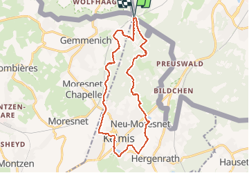
9.6 km | 12.1 km-effort
2h 44min
![](https://static1.geolcdn.com/siteimages/upload/files/16400158638029165_repeat_loop_refresh_sync_direction_icon.png)
Yes
![Trail Walking Raeren - 2023-09-21_15h54m11_392.gpx.xml - Photo](https://media.geolcdn.com/t/375/260/ext.jpg?maxdim=2&url=https%3A%2F%2Fmedia.geolcdn.com%2Ff%2F3a31813f-998d-4148-baa8-502439fc02b8.jpg)
![Walking Walking](https://static1.geolcdn.com/sitytour/trail-icons/101.png)
2023-09-21_15h54m11_392.gpx.xml
Walking
Medium
(1)
Raeren,
Wallonia,
Liège,
Belgium
![](/images/other/stat-length.png)
13.2 km | 17.3 km-effort
3h 55min
![](https://static1.geolcdn.com/siteimages/upload/files/16400158638029165_repeat_loop_refresh_sync_direction_icon.png)
Yes
![Trail Walking Vaals - 2023-04-07_19h11m12_788 - Photo](https://media.geolcdn.com/t/375/260/ext.jpg?maxdim=2&url=https%3A%2F%2Fmedia.geolcdn.com%2Ff%2Fbd8f5c72-b581-4e46-b6f7-9a77fca5b16a.jpg)
![Walking Walking](https://static1.geolcdn.com/sitytour/trail-icons/101.png)
2023-04-07_19h11m12_788
Walking
Medium
(1)
Vaals,
Limburg,
Unknown,
Netherlands
![](/images/other/stat-length.png)
12.9 km | 16.3 km-effort
3h 42min
![](https://static1.geolcdn.com/siteimages/upload/files/16400158638029165_repeat_loop_refresh_sync_direction_icon.png)
Yes
![Trail Walking Vaals - 2023-04-07_19h07m33_235 - Photo](https://media.geolcdn.com/t/375/260/ext.jpg?maxdim=2&url=https%3A%2F%2Fmedia.geolcdn.com%2Ff%2F2b2b6b31-a826-484c-a3a8-d4c3abde9549.jpg)
![Walking Walking](https://static1.geolcdn.com/sitytour/trail-icons/101.png)
2023-04-07_19h07m33_235
Walking
Medium
(1)
Vaals,
Limburg,
Unknown,
Netherlands
![](/images/other/stat-length.png)
14.7 km | 18.3 km-effort
4h 9min
![](https://static1.geolcdn.com/siteimages/upload/files/16400158638029165_repeat_loop_refresh_sync_direction_icon.png)
Yes
![Trail Walking Kelmis - La Calamine - Photo](https://media.geolcdn.com/t/375/260/ext.jpg?maxdim=2&url=https%3A%2F%2Fmedia.geolcdn.com%2Ff%2F606e5792-434a-491a-b5eb-2bfc2ef6f1ed.jpg)
![Walking Walking](https://static1.geolcdn.com/sitytour/trail-icons/101.png)
![Trail Walking Aachen - Aix-la-Chapelle - Photo](https://media.geolcdn.com/t/375/260/ext.jpg?maxdim=2&url=https%3A%2F%2Fmedia.geolcdn.com%2Ff%2F19678e47-68ef-4997-bad3-67eb75fafd82.jpg)
![Walking Walking](https://static1.geolcdn.com/sitytour/trail-icons/101.png)
Aix-la-Chapelle
Walking
Easy
(1)
Aachen,
North Rhine-Westphalia,
Städteregion Aachen,
Germany
![](/images/other/stat-length.png)
11.4 km | 15.4 km-effort
3h 30min
![](https://static1.geolcdn.com/siteimages/upload/files/16400158638029165_repeat_loop_refresh_sync_direction_icon.png)
Yes
![Trail Walking Aachen - Aix-la-Chapelle - Photo](https://media.geolcdn.com/t/375/260/ext.jpg?maxdim=2&url=https%3A%2F%2Fmedia.geolcdn.com%2Ff%2Fefbe95f3-eeed-42aa-9acc-74aad4d18b78.jpg)
![Walking Walking](https://static1.geolcdn.com/sitytour/trail-icons/101.png)
Aix-la-Chapelle
Walking
Easy
(1)
Aachen,
North Rhine-Westphalia,
Städteregion Aachen,
Germany
![](/images/other/stat-length.png)
11.1 km | 13.4 km-effort
3h 2min
![](https://static1.geolcdn.com/siteimages/upload/files/16400158638029165_repeat_loop_refresh_sync_direction_icon.png)
Yes
![Trail Walking Vaals - 2022-11-11_17h47m43_wandelroute---cittaslow-rondje-viele - Photo](https://media.geolcdn.com/t/375/260/ext.jpg?maxdim=2&url=https%3A%2F%2Fmedia.geolcdn.com%2Ff%2Fcb720190-f2d4-42d1-99cb-3f9826e2bd6a.jpg)
![Walking Walking](https://static1.geolcdn.com/sitytour/trail-icons/101.png)
2022-11-11_17h47m43_wandelroute---cittaslow-rondje-viele
Walking
Medium
(1)
Vaals,
Limburg,
Unknown,
Netherlands
![](/images/other/stat-length.png)
12.8 km | 17.1 km-effort
3h 53min
![](https://static1.geolcdn.com/siteimages/upload/files/16400158638029165_repeat_loop_refresh_sync_direction_icon.png)
Yes
![Trail Walking Kelmis - 2022-01-18_14h17m25_kelmis - Photo](https://media.geolcdn.com/t/375/260/ext.jpg?maxdim=2&url=https%3A%2F%2Fmedia.geolcdn.com%2Ff%2F9eea9d75-ea39-4660-b255-7d2a2255555e.jpg)
![Walking Walking](https://static1.geolcdn.com/sitytour/trail-icons/101.png)
2022-01-18_14h17m25_kelmis
Walking
Easy
(1)
Kelmis,
Wallonia,
Liège,
Belgium
![](/images/other/stat-length.png)
14.2 km | 18.4 km-effort
4h 10min
![](https://static1.geolcdn.com/siteimages/upload/files/16400158638029165_repeat_loop_refresh_sync_direction_icon.png)
Yes