


GTVAU-PJ4

PhilippeC54
User
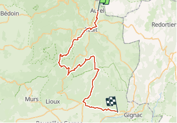

Length
58 km

Max alt
1009 m

Uphill gradient
1081 m
Km-Effort
74 km

Min alt
312 m

Downhill gradient
1456 m
Boucle
No
Creation date :
2021-05-24 07:26:18.252
Updated on :
2021-05-24 15:25:40.762
4h37
Difficulty : Difficult

FREE GPS app for hiking
 SityTrail
IGN / Geographical institutes
SityTrail Plus
The world is yours!
About
Trail Mountain bike of 58 km to be discovered at Provence-Alpes-Côte d'Azur, Vaucluse, Aurel. This trail is proposed by PhilippeC54.
Positioning
Country:
France
Region :
Provence-Alpes-Côte d'Azur
Department/Province :
Vaucluse
Municipality :
Aurel
Location:
Unknown
Start:(Dec)
Start:(UTM)
694198 ; 4889106 (31T) N.
Comments