


Batterie de Cuguret circuit et détours 2021/05/26

mapetite
User
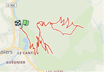

Length
11.2 km

Max alt
1873 m

Uphill gradient
697 m
Km-Effort
20 km

Min alt
1221 m

Downhill gradient
696 m
Boucle
Yes
Creation date :
2021-05-26 05:56:58.007
Updated on :
2021-05-26 14:06:26.959
4h52
Difficulty : Difficult

FREE GPS app for hiking
 SityTrail
IGN / Geographical institutes
SityTrail Plus
The world is yours!
About
Trail Walking of 11.2 km to be discovered at Provence-Alpes-Côte d'Azur, Alpes-de-Haute-Provence, Jausiers. This trail is proposed by mapetite.
Positioning
Country:
France
Region :
Provence-Alpes-Côte d'Azur
Department/Province :
Alpes-de-Haute-Provence
Municipality :
Jausiers
Location:
Unknown
Start:(Dec)
Start:(UTM)
320065 ; 4921479 (32T) N.
Comments