


L’ARSELLE

RD78-38
User
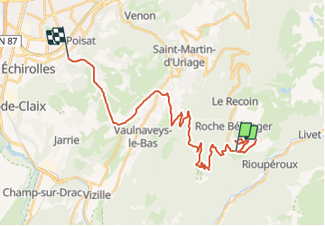

Length
32 km

Max alt
1788 m

Uphill gradient
330 m
Km-Effort
41 km

Min alt
234 m

Downhill gradient
1731 m
Boucle
No
Creation date :
2021-05-26 08:46:56.0
Updated on :
2021-05-26 14:18:24.143
2h40
Difficulty : Very easy

FREE GPS app for hiking
 SityTrail
IGN / Geographical institutes
SityTrail Plus
The world is yours!
About
Trail Walking of 32 km to be discovered at Auvergne-Rhône-Alpes, Isère, Chamrousse. This trail is proposed by RD78-38.
Description
Agréable battade
Positioning
Country:
France
Region :
Auvergne-Rhône-Alpes
Department/Province :
Isère
Municipality :
Chamrousse
Location:
Unknown
Start:(Dec)
Start:(UTM)
726399 ; 4998040 (31T) N.
Comments