


Val corbet

audrey54
User
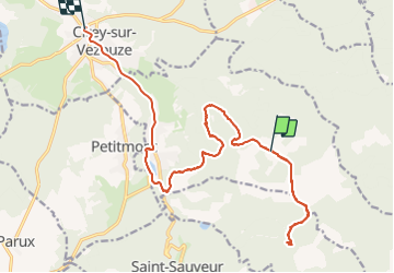

Length
18.3 km

Max alt
523 m

Uphill gradient
296 m
Km-Effort
23 km

Min alt
290 m

Downhill gradient
445 m
Boucle
No
Creation date :
2021-05-16 10:20:48.0
Updated on :
2021-05-26 14:40:33.758
5h45
Difficulty : Difficult

FREE GPS app for hiking
 SityTrail
IGN / Geographical institutes
SityTrail Plus
The world is yours!
About
Trail Walking of 18.3 km to be discovered at Grand Est, Meurthe-et-Moselle, Val-et-Châtillon. This trail is proposed by audrey54.
Positioning
Country:
France
Region :
Grand Est
Department/Province :
Meurthe-et-Moselle
Municipality :
Val-et-Châtillon
Location:
Unknown
Start:(Dec)
Start:(UTM)
352619 ; 5380261 (32U) N.
Comments