


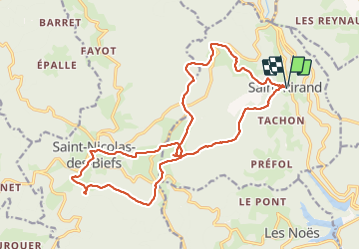
St Rirand 20km

thonyc
User GUIDE

Length
20 km

Max alt
1044 m

Uphill gradient
691 m
Km-Effort
29 km

Min alt
589 m

Downhill gradient
691 m
Boucle
Yes
Creation date :
2021-05-27 07:53:11.772
Updated on :
2021-05-31 09:58:13.021
6h00
Difficulty : Difficult

FREE GPS app for hiking
 SityTrail
IGN / Geographical institutes
SityTrail Plus
The world is yours!
About
Trail Walking of 20 km to be discovered at Auvergne-Rhône-Alpes, Loire, Saint-Rirand. This trail is proposed by thonyc.
Photos


Positioning
Country:
France
Region :
Auvergne-Rhône-Alpes
Department/Province :
Loire
Municipality :
Saint-Rirand
Location:
Unknown
Start:(Dec)
Start:(UTM)
565720 ; 5102791 (31T) N.
Comments