


Villette

luckyy
User
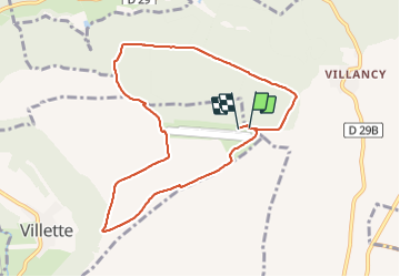

Length
8.2 km

Max alt
362 m

Uphill gradient
94 m
Km-Effort
9.4 km

Min alt
309 m

Downhill gradient
95 m
Boucle
Yes
Creation date :
2021-05-27 12:04:02.235
Updated on :
2021-05-27 14:24:25.234
2h19
Difficulty : Medium

FREE GPS app for hiking
 SityTrail
IGN / Geographical institutes
SityTrail Plus
The world is yours!
About
Trail Walking of 8.2 km to be discovered at Grand Est, Meurthe-et-Moselle, Villette. This trail is proposed by luckyy.
Positioning
Country:
France
Region :
Grand Est
Department/Province :
Meurthe-et-Moselle
Municipality :
Villette
Location:
Unknown
Start:(Dec)
Start:(UTM)
686723 ; 5484470 (31U) N.
Comments