


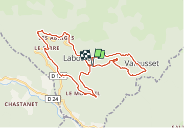
Laboule 27/05/21

Linerou
User

Length
11.4 km

Max alt
699 m

Uphill gradient
545 m
Km-Effort
18.7 km

Min alt
483 m

Downhill gradient
547 m
Boucle
Yes
Creation date :
2021-05-27 08:15:10.249
Updated on :
2021-05-27 14:26:51.538
3h59
Difficulty : Medium

FREE GPS app for hiking
 SityTrail
IGN / Geographical institutes
SityTrail Plus
The world is yours!
About
Trail Walking of 11.4 km to be discovered at Auvergne-Rhône-Alpes, Ardèche, Laboule. This trail is proposed by Linerou.
Positioning
Country:
France
Region :
Auvergne-Rhône-Alpes
Department/Province :
Ardèche
Municipality :
Laboule
Location:
Unknown
Start:(Dec)
Start:(UTM)
592915 ; 4937606 (31T) N.
Comments