


donptail en l'air

Nila81
User
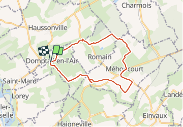

Length
13.8 km

Max alt
351 m

Uphill gradient
196 m
Km-Effort
16.4 km

Min alt
263 m

Downhill gradient
201 m
Boucle
Yes
Creation date :
2021-05-27 11:57:11.226
Updated on :
2021-05-27 15:05:22.183
3h06
Difficulty : Difficult

FREE GPS app for hiking
 SityTrail
IGN / Geographical institutes
SityTrail Plus
The world is yours!
About
Trail Walking of 13.8 km to be discovered at Grand Est, Meurthe-et-Moselle, Domptail-en-l'Air. This trail is proposed by Nila81.
Positioning
Country:
France
Region :
Grand Est
Department/Province :
Meurthe-et-Moselle
Municipality :
Domptail-en-l'Air
Location:
Unknown
Start:(Dec)
Start:(UTM)
302584 ; 5376919 (32U) N.
Comments