


Rosey Bissey sous Cruchaud Mont Brogny

pensionisten71
User
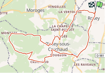

Length
13.1 km

Max alt
469 m

Uphill gradient
382 m
Km-Effort
18.2 km

Min alt
237 m

Downhill gradient
382 m
Boucle
Yes
Creation date :
2021-05-30 11:17:41.238
Updated on :
2022-01-07 16:48:26.656
3h12
Difficulty : Easy

FREE GPS app for hiking
 SityTrail
IGN / Geographical institutes
SityTrail Plus
The world is yours!
About
Trail Walking of 13.1 km to be discovered at Bourgogne-Franche-Comté, Saône-et-Loire, Rosey. This trail is proposed by pensionisten71.
Description
voir photos
Photos


Positioning
Country:
France
Region :
Bourgogne-Franche-Comté
Department/Province :
Saône-et-Loire
Municipality :
Rosey
Location:
Unknown
Start:(Dec)
Start:(UTM)
630364 ; 5178403 (31T) N.
Comments