


Balade truite

magbjo
User
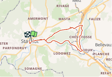

Length
12.6 km

Max alt
428 m

Uphill gradient
247 m
Km-Effort
15.9 km

Min alt
276 m

Downhill gradient
258 m
Boucle
No
Creation date :
2021-05-30 12:18:08.0
Updated on :
2021-05-30 15:19:28.444
3h01
Difficulty : Difficult

FREE GPS app for hiking
 SityTrail
IGN / Geographical institutes
SityTrail Plus
The world is yours!
About
Trail Walking of 12.6 km to be discovered at Wallonia, Liège, Stavelot. This trail is proposed by magbjo.
Positioning
Country:
Belgium
Region :
Wallonia
Department/Province :
Liège
Municipality :
Stavelot
Location:
Unknown
Start:(Dec)
Start:(UTM)
708318 ; 5586572 (31U) N.
Comments