


la villette3

Houel
User
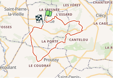

Length
14.6 km

Max alt
255 m

Uphill gradient
380 m
Km-Effort
19.7 km

Min alt
77 m

Downhill gradient
400 m
Boucle
No
Creation date :
2021-05-30 11:41:48.415
Updated on :
2021-05-30 16:14:26.758
4h21
Difficulty : Medium

FREE GPS app for hiking
 SityTrail
IGN / Geographical institutes
SityTrail Plus
The world is yours!
About
Trail Walking of 14.6 km to be discovered at Normandy, Calvados, La Villette. This trail is proposed by Houel.
Positioning
Country:
France
Region :
Normandy
Department/Province :
Calvados
Municipality :
La Villette
Location:
Unknown
Start:(Dec)
Start:(UTM)
679939 ; 5420621 (30U) N.
Comments