


marksteins

fc172632
User
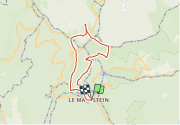

Length
13.2 km

Max alt
1263 m

Uphill gradient
353 m
Km-Effort
17.9 km

Min alt
1105 m

Downhill gradient
350 m
Boucle
Yes
Creation date :
2021-05-31 08:23:44.052
Updated on :
2021-06-01 07:36:00.254
4h12
Difficulty : Medium

FREE GPS app for hiking
 SityTrail
IGN / Geographical institutes
SityTrail Plus
The world is yours!
About
Trail Walking of 13.2 km to be discovered at Grand Est, Haut-Rhin, Ranspach. This trail is proposed by fc172632.
Positioning
Country:
France
Region :
Grand Est
Department/Province :
Haut-Rhin
Municipality :
Ranspach
Location:
Unknown
Start:(Dec)
Start:(UTM)
353156 ; 5309639 (32T) N.
Comments